
A mother and daughter look over their Fort Worth home that was destroyed by May 1949 flooding. Courtesy, Fort Worth Star-Telegram Collection, Special Collections, The University of Texas at Arlington Libraries
The Endless Cycle of Rebuilding After a Flood
Todd Kerstetter chronicles the constant power struggle that comes with attempting to create a life along a river.
It was the flood that swallowed central Fort Worth. In May 1949, a 10-inch deluge transformed the Trinity River into a 14-block-wide lake. Floodwaters inundated one neighborhood after another, forcing thousands to evacuate. The water treatment plant was knocked out of service, leaving much of the city without safe drinking water for days. The eight-story Montgomery Ward building stood as one of the few visible landmarks, overlooking block after block where rooftops barely broke the water’s surface.
The flood caused $15 million in damage ($161 million in 2019 dollars), killed at least 10 people and left 13,000 homeless. The water encompassing the Fort Worth Zoo and Colonial Country Club was knee- to shoulder-deep.
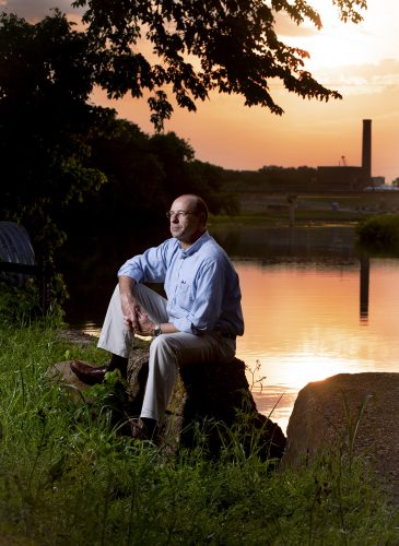
Todd Kerstetter, professor of history, studies the patterns of human settlement around rivers — and how people continually rebuild after floodwaters disrupt their lives. Photo by Joyce Marshall
River water is not only a source of life but a threat to it as well. This perilous contradiction is both a lesson from history and a recurring danger. In spring 2019, floods across the Midwest and Great Plains caused several billion dollars in damage to infrastructure, farms and residences.
Todd Kerstetter studies the ways that rivers and flooding order and disrupt civilization. “By chronicling people’s experiences of living along rivers and the mistakes they’ve made,” the history professor said, “I’m trying to shed light on how people can better coexist with rivers in the future.”
The irresistible draw of rivers — for nourishment, for transportation, for commerce — has spurred settlement as far back as the earliest civilizations along the Tigris and Euphrates.
Over time, however, development often intervenes in a river’s course and infringes on flood plains, the low-lying areas surrounding a river. When rivers do what they are prone to — flood — the power of nature can suddenly sweep away humans’ best-laid plans.
The battles of river-versus-civilization, repeated across time and place, have long piqued Kerstetter’s interest. Early in his academic career, he focused on the 290-mile-long Elkhorn River, which rolls through the plains of northeast Nebraska. He found that the ebbs and flows of life in the small towns along the Elkhorn’s banks reflected universal truths about how rivers alter communities.
He shared his observations of how the Elkhorn inspired and impeded generations of settlers in towns such as West Point and Norfolk in his book Flood on the Tracks: Living, Dying, and the Nature of Disaster in the Elkhorn River Basin (Texas Tech University Press, 2018). “I wanted to tell this story from the Elkhorn’s perspective in the hopes that it might point to a different or deeper understanding of the history of flooding in the region,” he said.
At the outset of his research, Kerstetter chronicled the history of flooding in the Elkhorn River Basin through 1944, the worst flood year on record at the time. Flooding in May and June 1944 damaged hundreds of businesses and homes, wiped out crops and livestock across multiple counties, and disrupted key rail lines for months.
When Kerstetter circled back to the topic 25 years later, he found a new flood record had been set in 2010. “It struck me that there was an immediacy … that made this story worth telling up to the present,” he said. He also found all-too-familiar cycles: Variables in the 1940s repeated themselves every decade.
“In fact, things had maybe gotten more pronounced,” he said. “It was kind of, at the same time, encouraging and discouraging to see these themes just kept repeating.”
River Cities
As Kerstetter recounts in Flood on the Tracks, a pamphlet published in 1880 promoted the Elkhorn River Basin to prospective settlers as “one of the finest and completest river and creek systems to be found anywhere between the oceans,” capable of “delivering immense water power.”
“As I was putting the book together, I recall shaking my head, saying, ‘This is just one damn flood after another, and nobody seems to do anything.’ ”
Todd Kerstetter
That power attracted some of the basin’s earliest non-Native American settlers to establish a sawmill at a site called West Point in 1859. They built a brush dam on the river to increase the force of the water powering the mill’s wheel. “Some thought it the best water power in the state,” Kerstetter wrote. A flour mill was added in 1868.
The mill enterprise made West Point a commercial and social hub. Ancillary businesses sprang up, including a planing mill, paper mill and furniture factory, all powered by the mighty Elkhorn.
However, as Kerstetter wrote, “The settlers’ desire to be near, and reap the benefits of, rivers presented a problem: Proximity bred not only profits but danger and destruction. As technology brought permanent residents into the Elkhorn’s flood plains, it gave them false confidence they could control the river and protect themselves and their possessions from flooding.”
That hubris was evident in spring 1873, when floodwaters inundated West Point and nearby farms, causing extensive damage to roads, crops and mill dams. Downstream, floodwaters compromised a railroad bridge and caused a train bound for California to derail, dumping a $30,000 cargo that included lobsters and oysters. The response to this and subsequent floods along the river varied little: People cleaned up, rebuilt and continued life in place.
“As I was putting the book together, I recall shaking my head, saying, ‘This is just one damn flood after another, and nobody seems to do anything,’ ” Kerstetter said. “It just keeps happening, and the results don’t really seem to be any different.”
A Complicated Reckoning
Early flood control efforts were hodgepodge: a dike here, a levee there, all intended to protect property from rising waters.
The dawn of the Progressive Era in the early 1900s, a period of widespread social and economic reform, sparked the creation of the first community drainage districts along the Elkhorn. These organizations were dedicated to improving the river, Kerstetter said. “They would modify the river channels to facilitate drainage and do things like straighten the channel or try to deepen the channel.
“In some ways, that did help mitigate some of the flood damage. But in other ways, it helped exacerbate it because the river would flow more quickly. … And in some cases that sped up erosion, or it might have diverted water from a settlement and sent it down onto somebody else’s property downstream in ways that were more destructive than it might have been otherwise.”
“There has long been a common attitude — call it optimism, arrogance or hubris — in terms of how people think they can control rivers.”
Todd Kerstetter
The disaster in 1944 brought a new player into flood management in the basin: the U.S. government. Federal agencies such as the Army Corps of Engineers expanded their purview to include flood control after the massive floods along the Mississippi River in 1927. That activity ramped up after the 1944 devastation along the Elkhorn.
Norfolk, Nebraska, with a population of roughly 10,500, bore the brunt of the ’44 flood, which covered a footprint of 176 city blocks and caused damage estimated at more than $1.2 million ($17.5 million in today’s dollars). High water damaged 459 homes and 177 businesses, many of which had to discard contaminated inventory. Telephone, power and railroad services were disrupted. A shortage of manpower because of World War II slowed the labor-intensive cleanup.
Beyond Norfolk, crops were wiped out, and poultry and hogs drowned. The wreckage was most severe along upper Elkhorn River Basin, but a few towns farther downriver, including West Point, reported flooded basements and disruptions in rail traffic.
Efforts to Control
The Elkhorn flood and other contemporaneous ones across the Great Plains propelled Congress to pass the Pick-Sloan Plan of 1944. Its intent was to oversee flood-control projects throughout the Missouri River Basin, a watershed covering more than 500,000 miles across 10 states.
The Omaha District of the Army Corps of Engineers launched a thorough investigation of the Elkhorn flood’s damage and drafted a detailed, comprehensive plan for flood control and protection.
The Corps’ final report included four improvement plans and a dozen recommendations for local projects, including levees, channel diversions and modifications to dam spillways, all to improve drainage.
However, with federal budgets strained after World War II and resistance from some of the myriad municipalities involved, the plans were never implemented. Barriers such as land easements and local votes against specific projects contributed to the sweeping plans’ downfall. The Corps’ plans raised awareness that the basin should be treated as a whole unit, rather than piecemeal, but “from a cost-analysis perspective, it was just prohibitive to do that,” Kerstetter said.
Only five of the Corps-recommended local projects were put into action, he said. Even those were enacted only after a series of floods in the 1960s once again wreaked havoc.
“Think about giving rivers a little bit more space to do what they can be counted on to do.”
Todd Kerstetter
The rise of the environmental movement in the late 1960s coincided with a shift in policy perspective, away from “taming” the rivers to acknowledging the inevitability of flooding and the role that river modification and settlement patterns played in past flood damage.
The Nebraska Flood Plain Management Act limited development in flood plains in 1968. “One of my favorite quotes I found in researching the book is, ‘Building in a flood plain is like pitching your tent on a highway when there are no cars coming,’ ” Kerstetter said. Subsequent programs by the Federal Emergency Management Agency would reinforce that theme by giving municipalities federal grants to buy properties in flood plains.
Also in 1968, the enactment of the National Flood Insurance Program required communities to adopt zoning restrictions in flood-prone areas to qualify for flood insurance.
From Kerstetter’s perspective, flood insurance created unintended consequences still felt today. “People thought, ‘Well, OK, my house is in a river flood plain. I can stay there; I have flood insurance. If it floods, I’ll get an insurance settlement and be OK,’ ” he said. “Whereas I think the better option in a lot of cases might be, ‘I have a house in a flood plain; I should move.’ I think it encouraged people to stay and … also, unfortunately, helped encourage some development of flood plains that might not ought to have happened.”
The ongoing conversation about life along rivers has taken on a new dimension in the 21st century, as climate change has been credited with intensifying storms.
In 2010, a historic flood swept along the Elkhorn and devastated infrastructure throughout the basin. Water covered countless roads, broke the water supply line to the town of Stanton and knocked out several bridges, killing one railroad employee.
Public calls afterward to fix the channel sounded eerily familiar, Kerstetter said, as yet another generation saw life disrupted by the river.
“I would hope anybody who lives near a river or water would think about the nature of their relationship with that waterway,” he said, “and to think about giving rivers a little bit more space to do what they can be counted on to do.”
The Beautiful Banks
Fort Worth learned plenty of lessons after the epic 1949 flood.
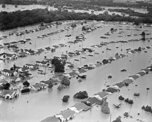
An aerial view of a neighborhood at the north end of Crestwood Drive following the flooding of May 17, 1949. During the flooding, the Trinity River turned into a 14-block-wide lake that covered nearby neighborhoods. Courtesy, Fort Worth Star-Telegram Collection, Special Collections, The University of Texas at Arlington Libraries
The raging waters “broke through the levee system that had been developed and built up to that point,” said Quentin McGown, a Fort Worth historian who has presented the extended education class The Trinity River: Its History and Evolution through TCU’s Center for Texas Studies.
In the aftermath of the 1949 flood, the Tarrant Regional Water District, in conjunction with the Army Corps of Engineers, took over responsibility for improving the Trinity’s levee system. The result was the 27-mile Fort Worth Floodway, an improved channel that uses levees, low-water dams and floodgates to control the flow of the Trinity through the heart of the city.
“The floodway was actually designed for probably much greater capacity than it would have been otherwise because of the ’49 flood,” said David Marshall, director of engineering and operations support for the 11-county water district. “Most areas have 100-year, 150-year flood control levees. Ours are more in the order of a 500-year flood.”
As a result, Marshall said, Fort Worth hasn’t seen a major flood since 1949. The excess capacity built into the floodway has enabled it to handle the increased runoff that has come with the Dallas-Fort Worth area’s status as the country’s fastest-growing metro area by population in 2018, according to the U.S. Census Bureau.
The flood-control system changed the very nature of the Trinity: The added concrete didn’t appear very natural.
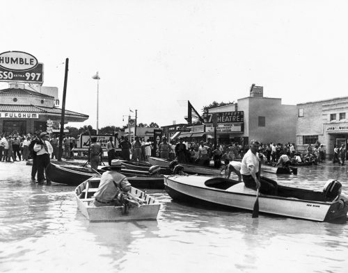
People use boats to navigate the intersection of University Drive and West Seventh Street, May 1949. Courtesy, W. D. Smith Commercial Photography Collection, Special Collections, The University of Texas at Arlington Libraries
In the 1970s, the nonprofit organization Streams & Valleys set out to reclaim and beautify the river and develop it as a recreational amenity. The results of those efforts are on full display. More than 72 miles of trails now run along the river. More than 8,000 trees have been planted. Low-water dams installed by the water district allow a steady enough flow of water for recreational use.
“Fort Worth existed because of the river,” McGown said, “then we turned our back on it for half a century. Everything we’re doing now is to refocus life around the river.”
On summer Sundays at Panther Island Pavilion, near the confluence of the Clear and West forks of the Trinity River, revelers float in inner tubes and move around on paddleboats, kayaks and paddleboards. This picture-perfect version of the Trinity is a far cry from the river known to previous generations: the river labeled as “septic” in the 1920s because of waste and manure pollution from the Fort Worth Stockyards and the river that swallowed Fort Worth in 1949.
For now, this stretch of the Trinity seems to be resting in safe status. “It’s an amazing turnaround,” Marshall said.

These days, Fort Worth’s Trinity River is a place for recreational activities such as tubing at Panther Island Pavilion, near where the Clear and West forks converge. Courtesy of Fort Worth Convention and Visitors Bureau (Aspen Productions)
However, the Tarrant Regional Water District and its partners in the Trinity River Vision Authority do not take the calm waters for granted. Every quarter, water district staff meets with local and federal authorities to discuss the water supply and flood-control preparations so that they are prepared should the river rise back into the danger zone.
Because another historic flood could be around the bend.
“There has long been a common attitude — call it optimism, arrogance or hubris — in terms of how people think they can control rivers,” Kerstetter said. “As we continue to build in flood plains and progress further into this era of climate change, we can’t afford to be overconfident and assume that our safeguards against rivers will continue to hold.”
Your comments are welcome
Comments
Related reading:
Research + Discovery
Why Motorists Risk Driving on Flooded Roads
Ashley Coles studies why drivers take their chances in high water, and how cities can prevent such risk-taking.
Features, Research + Discovery
In Early Modern Spain, Food Had Social Implications
Professor Jodi Campbell dishes on the meaning behind the meal in 15th-century Spain.
Features
‘Come From Away’ Inspiration Beverley Bass Tells Her Story
An American Airlines pilot got diverted on 9/11, and her story has landed on Broadway.