Why Motorists Risk Driving on Flooded Roads
Ashley Coles studies why drivers take their chances in high water, and how cities can prevent such risk-taking.
Why Motorists Risk Driving on Flooded Roads
Ashley Coles studies why drivers take their chances in high water, and how cities can prevent such risk-taking.
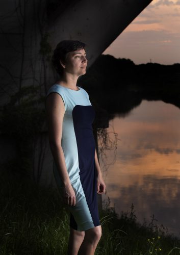
Ashley Coles, assistant professor of geography, found that motorists were willing to take an alternative route to avoid floods. Photo by Joyce Marshall
Respecting the power of water is at the center of Ashley Coles’ research. The assistant professor of geography studies how humans interact with the environment, especially as it relates to natural hazards such as flooding. In particular, she has examined factors that influence a driver’s decision to cross a flooded road.
There’s a reason the National Weather Service still runs its “Turn Around Don’t Drown” public service campaign 15 years after its launch. The Centers for Disease Control and Prevention reports that more than half of all flood-related drownings occur when someone drives into floodwater. The agency warns that just 12 inches of fast-moving water can carry away most cars. Yet drivers frequently underestimate the force of shallow water, with serious consequences.
Coles surveyed drivers in Tucson, Arizona, a city known for heavy summer rains that cause flooding at low-water crossings. Drivers’ reasons for crossing flooded roads sounded reasonable: They were running late, their family was on the other side of the flooded road, conditions were getting worse, the water didn’t look that deep. The top reason: A previous car had crossed without problems.
Coles found that while people trusted flood signs and barricades, they assumed the warnings indicated the likelihood, rather than the degree, of flash-flood danger.
“The signs are in place even if it is dry or [water is] maybe just a couple of inches deep,” Coles said. As a result, “people are relying more on what they can actually see around, and they’re looking for further information to confirm that this is indeed a dangerous flood situation.”
If another vehicle crossed the water without incident, respondents said, they gauged the height of that vehicle and the ripples created by the vehicle’s tires to decide whether to follow in its wake.
Coles was intrigued by one common response: “A lot of people said they were absolutely willing to take an alternative route, and often at great distances, if it meant they could avoid floods,” she said.
They just didn’t know which way to turn.
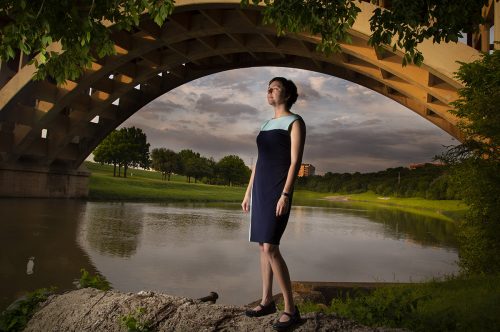
Ashley Coles, assistant professor of geography, said if useful information is available to people, they are likely to use it and keep themselves safe. Photo by Joyce Marshall
During summer 2019, Coles met with the Pima County Regional Flood Control District and the city of Tucson’s Department of Transportation, Safety and Logistics to discuss developing maps of alternate routes so drivers could have a plan B at their fingertips should a flood hazard arise.
For a model, she could turn to Fort Worth’s flood information website, which includes a map that provides real-time flood warning risk levels. Its data feed comes from 52 high-water warning flashers that stand sentinel over flood-prone traffic areas. The signals are activated when sensors detect rising water. On the map, green symbols signify that there is no threat; yellow means there is a potential for flooding; red means the road is flooded.
“If a good source of information exists,” Coles said, “and people know where to find it, they are likely to use it to keep themselves safe from floods.”
Your comments are welcome
Comments
Related reading:
Research + Discovery
The Endless Cycle of Rebuilding After a Flood
Todd Kerstetter chronicles the constant power struggle that comes with attempting to create a life along a river.
Alumni, Features
Crowdsourcing Can Lead to Solving Crimes with Police
Johnny Nhan analyzed how citizens banded together on platforms like Reddit to find the Boston Marathon bombers.
Campus News: Alma Matters
Is a National Energy Policy a Good Idea?
Faculty experts offer a range of opinions.