February 21, 2022
From the Depths of History
An illustrated map from 1493 gives visitors a new reason to stop by the library.
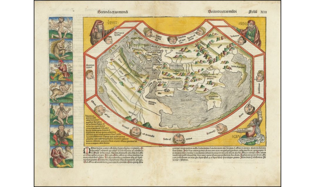
This rare 1493 illustrated map of the world came from the Liber Chronicarum, also known as the Nuremberg Chronicle. The map may be the last world drawing not to depict the Americas.
February 21, 2022
From the Depths of History
An illustrated map from 1493 gives visitors a new reason to stop by the library.
Now on view in the Mary Couts Burnett Library is a world map drawn through a 15th-century understanding. Illustrations of legendary, not-quite-human characters, as journaled by classical and medieval explorers, tile vertically down the left side. Puff-cheeked “wind heads” represent Ptolemy’s twelve winds; Noah’s three sons hold up the map’s edges. The world as it was understood in Germany in 1493 is on a slightly stained piece of paper, once a part of the Liber Chronicarum, also known as the Nuremberg Chronicle, which recorded history in text and illustrations.
“It’s just a very strange looking map … it’s a really unique piece,” said Tracy Hull, dean of the library. Other features on the page include Latin in blackletter typeface and hand-colored details on the Ptolemaic projection.
Though it was printed just after Christopher Columbus landed in the New World, the map does not include the Americas. This was surely a facepalm moment for Nuremberg publisher Anton Koberger, since word of the discovery had not yet made it to Germany, making this the last printed world map with this exclusion.
This recent acquisition was made possible through the Sumner Family Endowment. The reason for this map’s purchase by the library? “It was a combination of factors,” said Julie Christenson, rare book librarian. “The maps get a lot of use, and this complements the maps we already have but is unlike any of them.”
The George T. Abell cartographic collection in the library’s special collections serves undergraduate classes ranging from history to English to music to the Brite Divinity School. “There’s a lot that students can get out of a map without having any specialized skills,” Christenson said. “Students today are very attuned to visual rhetoric, and early maps were works of art as well as geographical representations of space.”
Consult the special collections hours before wandering up to the library’s third floor to visit the map. (You will also be asked to leave your Starbucks drink outside).
Your comments are welcome
Comments
Related reading:
Features
A Look Inside Special Collections
The library’s vault of historic writings and artifacts chronicles the history of TCU and Fort Worth.
Campus News: Alma Matters
Infographic – Library Facts
We break it down, book-by-book.
Campus News: Alma Matters
Q&A with Library Dean June Koelker
Mary Couts Burnett Library’s east wing reopened in October with new technology and more seating space. Dean Koelker spoke with us about the upgrade.